
Friday, September 4
Damp and Humid Conditions Prevail Across Kentucky
A weak atmospheric impulse will bring widespread but light rainfall to the Commonwealth, followed by a gradual clearing trend from west to east by late evening. Temperatures will remain warm and muggy with high humidity levels.
Confidence Assessment
Confidence is high for the occurrence of rain but tempered by the forecast being six days out (-25) and the volatility of light rain/cloud cover timing (-5).
Get Personalized Forecasts
Choose which region in Kentucky you're interested in and we'll always show you that one first. You can change your selected region by clicking the "Star" icon on any regional forecast.
Purchase Area
Expect a damp start with light rain most frequent during the morning hours. Rainfall totals will be light, around 0.12 inches. Clouds will linger into the afternoon keeping conditions muggy, though temperatures will still reach the low 90s.
Northwest Pennyrile
Light rain will be common throughout the morning and afternoon, totaling approximately 0.15 inches. Constant cloud cover will keep roads damp until a potential late-day appearance of the sun.
Southwest Pennyrile
A very warm and humid day with light rain occurring on and off. Expect around 0.16 inches of rainfall. Midday will see the most consistent rain, with muggy conditions persisting into the evening.
Barren River
A gray day is in store with light rain most frequent from late morning through mid-afternoon. Total rainfall is expected to be near 0.18 inches with high humidity throughout the day.
Louisville Metro
Rain will be most prevalent during the early morning hours, impacting the commute. Expect about 0.16 inches. Rain should taper off by late afternoon, leaving a cloudy and humid evening for the metro area.
Lincoln Trail
Light rain will move through the region during the morning and early afternoon, totaling around 0.17 inches. Overcast skies and high humidity will persist, with clearing delayed until later tonight.
Lake Cumberland
A soggy day is expected around the lake with rain steadiest during the late morning and afternoon. Total rainfall consensus is 0.19 inches with clouds lingering through the day's end.
Northern Kentucky
Light rain will be common through the morning hours, totaling 0.15 inches. Drying should begin by late afternoon, though humidity will remain high under mostly cloudy skies.
Inner Bluegrass
Light rain will likely impact the morning commute and midday plans. Expect around 0.16 inches of accumulation. Rain should taper off by late afternoon, though high humidity will remain into the evening.
Bluegrass Foothills
A wet day is expected with light rain showers on and off through the morning and afternoon. Expect about 0.18 inches of rain and very humid conditions under gray skies.
Northeast Kentucky
Rain will move into the area early and persist for most of the day, totaling around 0.19 inches. Expect damp roads and gray skies, with the steadiest rain expected during the morning hours.
Southeast Kentucky
Light rain will be frequent across the mountains today, totaling about 0.21 inches. Higher elevations may see more persistent showers, leading to a gray and muggy day.
Possible Outcomes
Weather forecasting involves uncertainty. Below are two scenarios representing the range of possible outcomes: the "Boom" scenario shows the worst-case/highest-impact result if conditions align unfavorably, while the "Bust" scenario shows the best-case/lowest-impact result if the forecast doesn't materialize as expected.
The 'Boom' Scenario
If localized instability (CAPE) develops higher than current guidance, rainfall totals could exceed 0.50 inches in convective bursts, primarily in the Southeast Coalfields.
The 'Bust' Scenario
If drier mid-level air filters in faster than modeled, precipitation may be limited to patchy drizzle and lingering cloud cover with minimal accumulation.
Model Disagreements
When models disagree, a call must be made to determine the most likely outcome. This decision is based on a combination of factors including model performance, historical data, and the models general accounting of each climatic region of Kentucky.
The Moisture Smear Conflict
Disagreement exists regarding the southern extent and intensity of light rain. Global models differ on whether the column saturates fully or if mid-level dry air limits totals to trace amounts.
Why EURO Wins
The Euro handles dry slots and moisture cutoffs with higher precision than the GFS, which tends to over-forecast light precipitation coverage (the 'Smear' effect).
Evening Clearing Progression
Timing differences in the shortwave exit affect when skies begin to clear for the evening commute in Central and Eastern Kentucky.
Why EURO Wins
Beyond the 48-hour window, global models like the Euro provide superior synoptic timing for weak wave exit speeds compared to the mesoscale NAM.
Celestial Almanac
Last Quarter
Purchase Area
Northwest Pennyrile
Southwest Pennyrile
Barren River
Louisville Metro
Lincoln Trail
Lake Cumberland
Northern Kentucky
Inner Bluegrass
Bluegrass Foothills
Northeast Kentucky
Southeast Kentucky
Forecast Charts
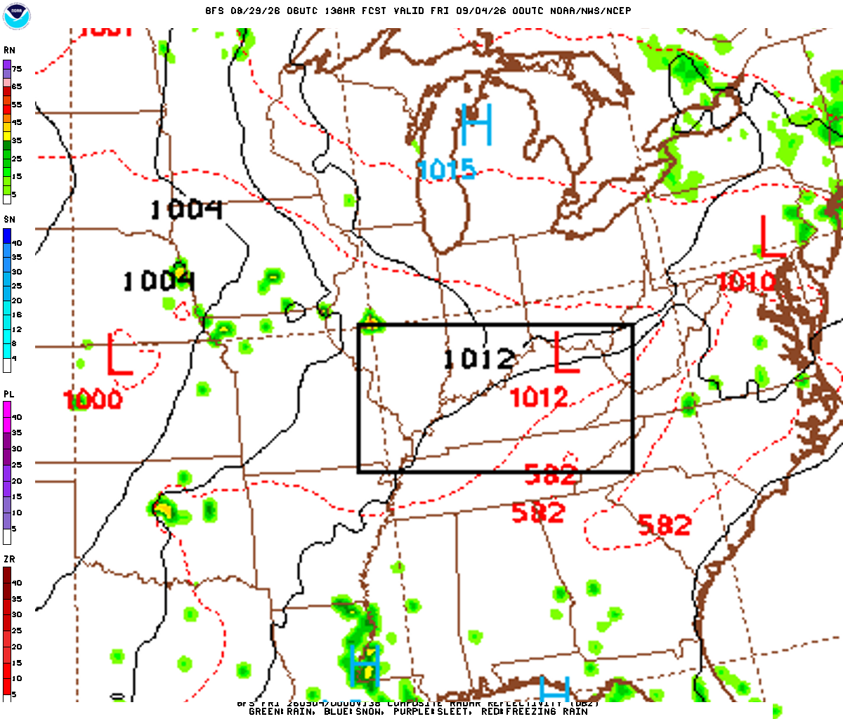
These maps are generated by the weather agencies based on the raw data that the weather models predict. The final forecast is generated using the same raw data shown on the map. Keep in mind that the models (and therefore the maps) will generally disagree on specific parts of the forecast. Use these as guidance - not as a final prediction.
Dive Deeper Into the Models
This forecast is a synthesis of raw data from the NAM, GFS, ECMWF, and GEM models. These models provide detailed atmospheric analyses including 500mb vorticity, precipitation rates, and more. You can take a look at the raw model data by clicking the links below.