
Saturday, July 18
NWS Alerts Active This Day
Air Quality Alert
Air Quality Alert issued July 17 at 12:43AM EDT by NWS Wilmington OH
The Southwest Ohio Air Quality Agency has issued an Air Quality Advisory for Butler, Clermont, Hamilton and Warren counties in Ohio; Boone, Campbell and Kenton counties in Kentucky; and Dearborn County in Indiana, until midnight EDT tonight. Fine particulate levels are expected to be in the 'Unhealthy for Sensitive Groups' range. Active children and adults, and people with respiratory disease, such as asthma should limit prolonged outdoor exposure. For additional information, please visit the Southwest Ohio Air Quality Agency's web site at www.southwestohioair.org/local_air_quality. Additionally, the Ohio Environmental Protection Agency has issued a statewide Air Quality Advisory for the entire state of Ohio as smoke from Canadian wildfires continues to adversely impact air quality. Pollutants across the state are expected to range from the 'Unhealthy For Sensitive Groups' category in the southwest part of the state to the 'Unhealthy' category in the rest of the state. Hourly concentrations at times may reach the 'Very Unhealthy' to 'Hazardous' categories. It is recommended, when possible, to avoid strenuous outdoor activities, especially those with heart disease and respiratory conditions like asthma. Watch for symptoms including wheezing, coughing, chest tightness, dizziness, or burning in the nose, throat, and eyes. For additional information, please visit the Ohio Environmental Protection Agency's website at epa.ohio.gov.
Muggy Saturday with Scattered Evening Thunderstorms
A typical summer pattern will dominate Kentucky this Saturday, characterized by high humidity and warm temperatures. While much of the day will feature sun and building clouds, a weak atmospheric disturbance will cross the Ohio Valley during the evening, triggering scattered showers and thunderstorms, primarily for northern and eastern sections of the state.
Confidence Assessment
Confidence is high for a muggy and warm day, but significantly lower regarding the exact timing and intensity of evening rain due to the massive discrepancy in instability (CAPE) between high-res and global models.
Get Personalized Forecasts
Choose which region in Kentucky you're interested in and we'll always show you that one first. You can change your selected region by clicking the "Star" icon on any regional forecast.
Purchase Area
Saturday will be a steam bath for Paducah and Murray. While a stray shower cannot be entirely ruled out in the morning, the majority of the day will be sunny and very hot. Expect temperatures to climb into the low 90s with high humidity making it feel even warmer.
Northwest Pennyrile
A mix of sun and clouds will define the day in Owensboro and Henderson. A few light showers are possible in the afternoon, but significant rain is unlikely. Highs will reach the upper 80s, and the air will remain very thick and humid.
Southwest Pennyrile
Hopkinsville will see off-and-on showers throughout the afternoon. It will not be a total washout, but outdoor plans may be briefly interrupted. The humidity will be high, with temperatures peaking in the high 80s.
Barren River
Bowling Green and Glasgow can expect a mostly dry morning followed by increasing clouds and a few showers by the evening hours. Gusty winds are possible this evening as a weak disturbance passes to the north.
Louisville Metro
Derby City will stay hot and muggy for most of the day, but a line of showers and thunderstorms is expected to move in after 6 PM. Some of these storms could bring heavy rain and gusty winds through the late evening hours.
Lincoln Trail
Expect intermittent rain showers in Elizabethtown and Bardstown, with the most likely timing in the late afternoon and evening. Temperatures will remain warm, reaching the mid-80s.
Lake Cumberland
A grey and humid Saturday is in store for Lake Cumberland. Periodic showers will be common, especially during the afternoon hours. Highs will stay in the low-to-mid 80s.
Northern Kentucky
Covington and Florence will likely see the most active weather tonight. Heavy rain and gusty winds are possible as a line of storms arrives after 6 PM. Total rainfall amounts will be around 0.35 inches.
Inner Bluegrass
Lexington will feel exceptionally muggy today. Rain chances increase significantly by the evening, with a few embedded thunderstorms possible. Expect accumulations around 0.3 inches by the time the rain tapers off tonight.
Bluegrass Foothills
Richmond and Berea will stay mostly cloudy and humid. Light rain showers will move through periodically, particularly in the afternoon. Highs will reach the mid-80s.
Northeast Kentucky
Ashland and Morehead will see the highest rainfall totals in the state today, with around 0.35 inches expected. Rain will be most frequent during the afternoon and evening hours.
Southeast Kentucky
Hazard and Pikeville will start the day with low clouds and drizzle. While the rain will be light, it will stay damp and humid through most of the day. Highs will stay in the low-to-mid 80s.
Possible Outcomes
Weather forecasting involves uncertainty. Below are two scenarios representing the range of possible outcomes: the "Boom" scenario shows the worst-case/highest-impact result if conditions align unfavorably, while the "Bust" scenario shows the best-case/lowest-impact result if the forecast doesn't materialize as expected.
The 'Boom' Scenario
The 'Boom' scenario occurs if the NAM's higher instability verifies and the capping inversion remains weak, leading to a widespread line of evening thunderstorms with gusty winds and heavy rain totals exceeding 0.75 inches in the Bluegrass and Northern KY.
The 'Bust' Scenario
The 'Bust' scenario occurs if the global models are correct regarding high cloud debris, which would stabilize the atmosphere, keeping conditions merely 'grey and damp' with light drizzle and significantly cooler temperatures.
Model Disagreements
When models disagree, a call must be made to determine the most likely outcome. This decision is based on a combination of factors including model performance, historical data, and the models general accounting of each climatic region of Kentucky.
The Stability Standoff
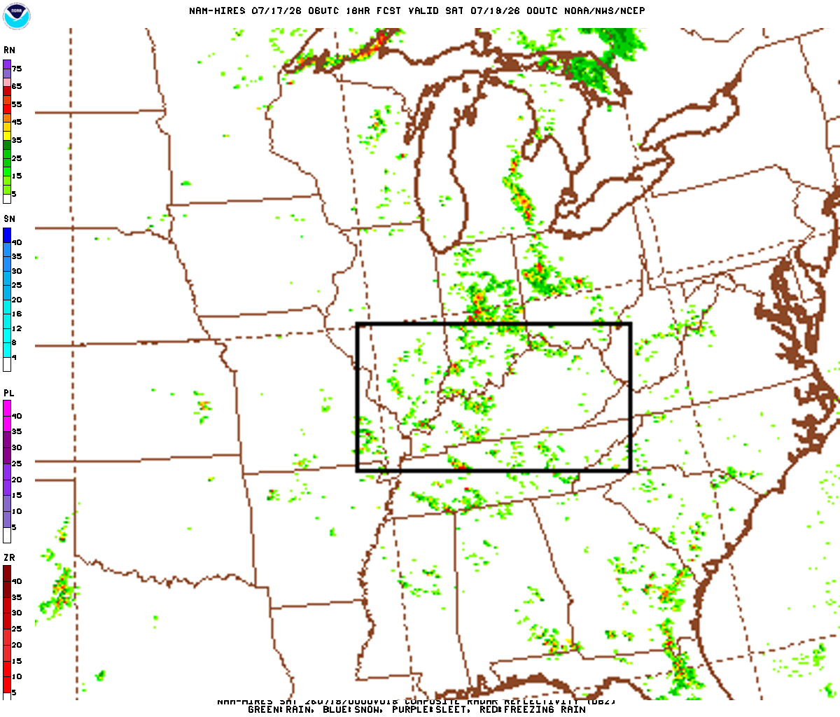
A major disagreement exists regarding thermodynamic instability. The NAM forecasts moderate CAPE (>1500 J/kg), supporting thunderstorms, while the GFS and Euro show near-zero instability, suggesting only light stratiform rain.
Why NAM Wins
In mid-July, the presence of high dewpoints and a crossing shortwave almost always results in convective instability. The global models are likely suffering from 'convective feedback' or poor vertical resolution of the boundary layer.
The Western Dry Slot
The GFS and Euro bring widespread 80% PoPs to Western Kentucky, while the NAM keeps the Purchase and Pennyrile regions mostly dry under a subsidence regime.
Why BLEND Wins
The NAM captures the subsidence behind the departing energy well, but the GFS/Euro moisture axis is too broad to ignore. A low-end rain chance is the safest compromise.
Celestial Almanac
Waxing Crescent
Purchase Area
Northwest Pennyrile
Southwest Pennyrile
Barren River
Louisville Metro
Lincoln Trail
Lake Cumberland
Northern Kentucky
Inner Bluegrass
Bluegrass Foothills
Northeast Kentucky
Southeast Kentucky
Forecast Charts
These maps are generated by the weather agencies based on the raw data that the weather models predict. The final forecast is generated using the same raw data shown on the map. Keep in mind that the models (and therefore the maps) will generally disagree on specific parts of the forecast. Use these as guidance - not as a final prediction.
Dive Deeper Into the Models
This forecast is a synthesis of raw data from the NAM, GFS, ECMWF, and GEM models. These models provide detailed atmospheric analyses including 500mb vorticity, precipitation rates, and more. You can take a look at the raw model data by clicking the links below.