
Friday, July 17
NWS Alerts Active This Day
Air Quality Alert
Air Quality Alert issued July 15 at 9:35PM EDT by NWS Wilmington OH
The Southwest Ohio Air Quality Agency has issued an Air Quality Advisory for Butler, Clermont, Hamilton and Warren counties in Ohio; Boone, Campbell and Kenton counties in Kentucky; and Dearborn County in Indiana, until midnight EDT Thursday night. Levels of ozone within the region may approach or exceed unhealthy standards. On Alert days, help reduce ozone by taking the following actions: * Carpool, if possible, bike, walk or take the bus instead of driving alone. * Refuel your vehicle after 8 pm. * Do not idle your vehicle, exhaust contributes to air pollution. * Mow your lawn in the evening hours and avoid the use of gas-powered lawn equipment. For additional information, please visit the Southwest Ohio Air Quality Agency's web site at www.southwestohioair.org/local_air_quality. Additionally, smoke from Canadian wildfires will adversely impact air quality on Thursday. The Ohio Environmental Protection Agency expects the Air Quality Index to be in the 'unhealthy for sensitive groups' range on Thursday. For additional information, please visit the Ohio Environmental Protection Agency's website at epa.ohio.gov.
Air Quality Alert
Air Quality Alert issued July 16 at 12:16AM EDT by NWS Wilmington OH
The Southwest Ohio Air Quality Agency has issued an Air Quality Advisory for Butler, Clermont, Hamilton and Warren counties in Ohio; Boone, Campbell and Kenton counties in Kentucky; and Dearborn County in Indiana, until midnight EDT tonight. Levels of ozone within the region may approach or exceed unhealthy standards. On Alert days, help reduce ozone by taking the following actions: * Carpool, if possible, bike, walk or take the bus instead of driving alone. * Refuel your vehicle after 8 pm. * Do not idle your vehicle, exhaust contributes to air pollution. * Mow your lawn in the evening hours and avoid the use of gas-powered lawn equipment. For additional information, please visit the Southwest Ohio Air Quality Agency's web site at www.southwestohioair.org/local_air_quality. Additionally, smoke from Canadian wildfires will adversely impact air quality on Thursday. The Ohio Environmental Protection Agency expects the Air Quality Index to be in the 'unhealthy for sensitive groups' range on Thursday. For additional information, please visit the Ohio Environmental Protection Agency's website at epa.ohio.gov.
Air Quality Alert
Air Quality Alert issued July 16 at 12:23AM EDT by NWS Wilmington OH
The Southwest Ohio Air Quality Agency has issued an Air Quality Advisory for Butler, Clermont, Hamilton and Warren counties in Ohio; Boone, Campbell and Kenton counties in Kentucky; and Dearborn County in Indiana, until midnight EDT tonight. Levels of ozone within the region may approach or exceed unhealthy standards. On Alert days, help reduce ozone by taking the following actions: * Carpool, if possible, bike, walk or take the bus instead of driving alone. * Refuel your vehicle after 8 pm. * Do not idle your vehicle, exhaust contributes to air pollution. * Mow your lawn in the evening hours and avoid the use of gas-powered lawn equipment. For additional information, please visit the Southwest Ohio Air Quality Agency's web site at www.southwestohioair.org/local_air_quality. Additionally, smoke from Canadian wildfires will adversely impact air quality on Thursday. The Ohio Environmental Protection Agency expects the Air Quality Index to be in the 'unhealthy for sensitive groups' range on Thursday. For additional information, please visit the Ohio Environmental Protection Agency's website at epa.ohio.gov.
Air Quality Alert
Air Quality Alert issued July 16 at 9:21AM EDT by NWS Wilmington OH
The Southwest Ohio Air Quality Agency has issued an Air Quality Advisory for Butler, Clermont, Hamilton and Warren counties in Ohio; Boone, Campbell and Kenton counties in Kentucky; and Dearborn County in Indiana, until midnight EDT tonight. Levels of ozone within the region may approach or exceed unhealthy standards. On Alert days, help reduce ozone by taking the following actions: * Carpool, if possible, bike, walk or take the bus instead of driving alone. * Refuel your vehicle after 8 pm. * Do not idle your vehicle, exhaust contributes to air pollution. * Mow your lawn in the evening hours and avoid the use of gas-powered lawn equipment. For additional information, please visit the Southwest Ohio Air Quality Agency's web site at www.southwestohioair.org/local_air_quality Additionally, smoke from Canadian wildfires will adversely impact air quality today. The Ohio Environmental Protection Agency expects the Air Quality Index to be in the 'unhealthy' range. For additional information, please visit the Ohio Environmental Protection Agency's website at epa.ohio.gov.
Air Quality Alert
Air Quality Alert issued July 16 at 10:53AM EDT by NWS Wilmington OH
The Southwest Ohio Air Quality Agency has issued an Air Quality Advisory for Butler, Clermont, Hamilton and Warren counties in Ohio; Boone, Campbell and Kenton counties in Kentucky; and Dearborn County in Indiana, until midnight EDT tonight. Levels of ozone within the region may approach or exceed unhealthy standards. On Alert days, help reduce ozone by taking the following actions: * Carpool, if possible, bike, walk or take the bus instead of driving alone. * Refuel your vehicle after 8 pm. * Do not idle your vehicle, exhaust contributes to air pollution. * Mow your lawn in the evening hours and avoid the use of gas-powered lawn equipment. For additional information, please visit the Southwest Ohio Air Quality Agency's web site at www.southwestohioair.org/local_air_quality Additionally, smoke from Canadian wildfires will adversely impact air quality today. The Ohio Environmental Protection Agency expects the Air Quality Index to be in the 'unhealthy' range. For additional information, please visit the Ohio Environmental Protection Agency's website at epa.ohio.gov.
Air Quality Alert
Air Quality Alert issued July 16 at 2:18PM EDT by NWS Wilmington OH
The Southwest Ohio Air Quality Agency has issued an Air Quality Advisory for Butler, Clermont, Hamilton and Warren counties in Ohio; Boone, Campbell and Kenton counties in Kentucky; and Dearborn County in Indiana, until midnight EDT tonight. Levels of ozone within the region may approach or exceed unhealthy standards. On Alert days, help reduce ozone by taking the following actions: * Carpool, if possible, bike, walk or take the bus instead of driving alone. * Refuel your vehicle after 8 pm. * Do not idle your vehicle, exhaust contributes to air pollution. * Mow your lawn in the evening hours and avoid the use of gas-powered lawn equipment. For additional information, please visit the Southwest Ohio Air Quality Agency's web site at www.southwestohioair.org/local_air_quality Additionally, smoke from Canadian wildfires will adversely impact air quality today. The Ohio Environmental Protection Agency expects the Air Quality Index to be in the 'unhealthy' range. For additional information, please visit the Ohio Environmental Protection Agency's website at epa.ohio.gov.
Air Quality Alert
Air Quality Alert issued July 16 at 3:18PM EDT by NWS Wilmington OH
The Southwest Ohio Air Quality Agency has issued an Air Quality Advisory for Butler, Clermont, Hamilton and Warren counties in Ohio; Boone, Campbell and Kenton counties in Kentucky; and Dearborn County in Indiana, until midnight EDT Friday night. Fine particulate levels are expected to be in the 'Unhealthy for Sensitive Groups' range. Active children and adults, and people with respiratory disease, such as asthma should limit prolonged outdoor exposure. For additional information, please visit the Southwest Ohio Air Quality Agency's web site at www.southwestohioair.org/local_air_quality. Additionally, the Ohio Environmental Protection Agency has issued a statewide Air Quality Advisory for the entire state of Ohio as smoke from Canadian wildfires continues to adversely impact air quality. Pollutants across the state are expected to range from the 'Unhealthy For Sensitive Groups' category in the southwest part of the state to the 'Unhealthy' category in the rest of the state. Hourly concentrations at times may reach the 'Very Unhealthy' to 'Hazardous' categories. It is recommended, when possible, to avoid strenuous outdoor activities, especially those with heart disease and respiratory conditions like asthma. Watch for symptoms including wheezing, coughing, chest tightness, dizziness, or burning in the nose, throat, and eyes. For additional information, please visit the Ohio Environmental Protection Agency's website at epa.ohio.gov.
Flood Advisory
Flood Advisory issued July 16 at 4:15PM CDT until July 16 at 7:15PM CDT by NWS Louisville KY
WHAT Flooding caused by excessive rainfall is expected.
WHERE Central Simpson County in south central Kentucky...
WHEN Until 715 PM CDT.
IMPACTS Minor flooding in low-lying and poor drainage areas. * ADDITIONAL DETAILS... - At 415 PM CDT, Doppler radar indicated heavy rain due to thunderstorms. Minor flooding is ongoing or expected to begin shortly in the advisory area. Between 0.5 and 1.5 inches of rain have fallen. - Additional rainfall amounts up to 1 inch are expected over the area. This additional rain will result in minor flooding. - Some locations that will experience flooding include... Franklin and Salmons. - http://www.weather.gov/safety/flood
Be aware of your surroundings and do not drive on flooded roads.
Air Quality Alert
Air Quality Alert issued July 17 at 12:43AM EDT by NWS Wilmington OH
The Southwest Ohio Air Quality Agency has issued an Air Quality Advisory for Butler, Clermont, Hamilton and Warren counties in Ohio; Boone, Campbell and Kenton counties in Kentucky; and Dearborn County in Indiana, until midnight EDT tonight. Fine particulate levels are expected to be in the 'Unhealthy for Sensitive Groups' range. Active children and adults, and people with respiratory disease, such as asthma should limit prolonged outdoor exposure. For additional information, please visit the Southwest Ohio Air Quality Agency's web site at www.southwestohioair.org/local_air_quality. Additionally, the Ohio Environmental Protection Agency has issued a statewide Air Quality Advisory for the entire state of Ohio as smoke from Canadian wildfires continues to adversely impact air quality. Pollutants across the state are expected to range from the 'Unhealthy For Sensitive Groups' category in the southwest part of the state to the 'Unhealthy' category in the rest of the state. Hourly concentrations at times may reach the 'Very Unhealthy' to 'Hazardous' categories. It is recommended, when possible, to avoid strenuous outdoor activities, especially those with heart disease and respiratory conditions like asthma. Watch for symptoms including wheezing, coughing, chest tightness, dizziness, or burning in the nose, throat, and eyes. For additional information, please visit the Ohio Environmental Protection Agency's website at epa.ohio.gov.
Sultry Friday with Localized Heavy Rain West
A hot and humid Friday is in store for Kentucky, with scattered afternoon showers and thunderstorms primarily affecting Western and Northern regions, while Central and Eastern Kentucky remain mostly dry and hot.
Confidence Assessment
Confidence is lowered by significant model disagreement regarding precipitation coverage (PoPs) and the inherent difficulty in timing pulse-style summer storms.
Get Personalized Forecasts
Choose which region in Kentucky you're interested in and we'll always show you that one first. You can change your selected region by clicking the "Star" icon on any regional forecast.
Purchase Area
A very warm day for the Purchase area with highs reaching the upper 80s. While some clouds will build in the evening, significant rainfall is unlikely.
Northwest Pennyrile
A dry morning will be followed by scattered rain showers moving in after sunset. Rainfall amounts will be around 0.1 inches.
Southwest Pennyrile
Expect a significant round of rain late this evening. Accumulations around 0.8 inches are expected, which may cause minor ponding on roads.
Barren River
Expect clouds to thicken in the afternoon with scattered rain showers. Total rain amounts will be around 0.2 inches.
Louisville Metro
A very hot and mostly dry day. Highs will reach the low 90s, with only a small chance for a stray evening shower.
Lincoln Trail
Mostly sunny for the majority of the day with a few light showers arriving late this evening. Accumulations will be less than 0.1 inches.
Lake Cumberland
Some light rain or drizzle is possible early in the morning, followed by a warm and partly sunny afternoon.
Northern Kentucky
Hot and steamy with highs near 92. Showers and perhaps a rumble of thunder are expected this evening.
Inner Bluegrass
A hot summer day with plenty of sunshine and highs reaching 90 degrees. No rain is expected for Lexington.
Bluegrass Foothills
Skies will remain mostly sunny with temperatures climbing into the upper 80s. A dry day is anticipated.
Northeast Kentucky
The warmest spot in the state today with temperatures reaching the mid-90s. Skies will stay clear.
Southeast Kentucky
A humid day with scattered rain showers throughout the afternoon. Accumulations around 0.2 inches are expected.
Possible Outcomes
Weather forecasting involves uncertainty. Below are two scenarios representing the range of possible outcomes: the "Boom" scenario shows the worst-case/highest-impact result if conditions align unfavorably, while the "Bust" scenario shows the best-case/lowest-impact result if the forecast doesn't materialize as expected.
The 'Boom' Scenario
If the NAM's localized vorticity spike verifies, the Southwest Pennyrile could see training convective clusters resulting in rainfall totals exceeding 1.5 inches and minor flash flooding.
The 'Bust' Scenario
If the GFS's mid-level dry air entrainment wins, most of the state will experience a 'Virga' event with only sprinkles reaching the ground and heat staying the primary headline.
Model Disagreements
When models disagree, a call must be made to determine the most likely outcome. This decision is based on a combination of factors including model performance, historical data, and the models general accounting of each climatic region of Kentucky.
The Bluegrass Dry Slot
The Euro brings widespread 80% PoPs into the Bluegrass Core, while the NAM and GFS suggest a 'dry slot' where subsidence suppresses rain for most of the day.
Why GFS Wins
The GFS 'Smear' effect is usually high, but in this instance, it matches the NAM's drier trend for Central KY. Given the weak forcing, the Euro is likely over-extending the coverage of light precip.
Convective Pulse vs. Stratiform Smear
The ECMWF forecasts a broad, low-impact stratiform rain shield with zero instability, whereas the NAM and GFS resolve localized convective clusters driven by daytime heating.
Why NAM Wins
In mid-July, vertical profiles with 0 CAPE as suggested by the Euro are climatologically unlikely during shortwave passages. The NAM's higher-resolution handling of pulse convection and boundary-layer heating is more physically sound for this time of year.
Celestial Almanac
Waxing Crescent
Purchase Area
Northwest Pennyrile
Southwest Pennyrile
Barren River
Louisville Metro
Lincoln Trail
Lake Cumberland
Northern Kentucky
Inner Bluegrass
Bluegrass Foothills
Northeast Kentucky
Southeast Kentucky
Forecast Charts
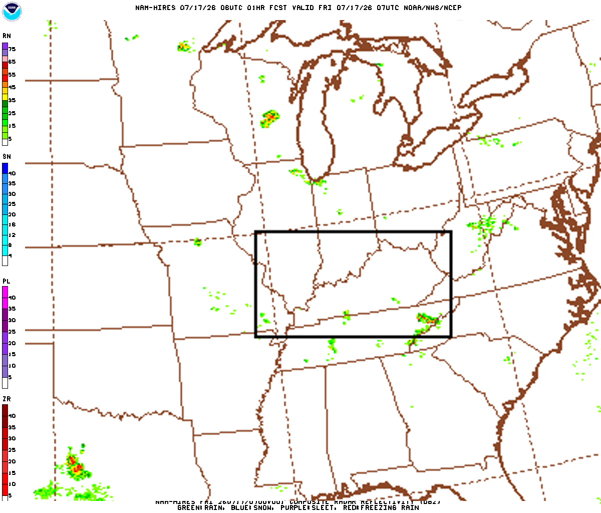
These maps are generated by the weather agencies based on the raw data that the weather models predict. The final forecast is generated using the same raw data shown on the map. Keep in mind that the models (and therefore the maps) will generally disagree on specific parts of the forecast. Use these as guidance - not as a final prediction.
Dive Deeper Into the Models
This forecast is a synthesis of raw data from the NAM, GFS, ECMWF, and GEM models. These models provide detailed atmospheric analyses including 500mb vorticity, precipitation rates, and more. You can take a look at the raw model data by clicking the links below.